One of the best ways to get around Yosemite National Park, I quickly figured out, is to hop one of the shuttle buses that work the valley. Shuttle to your trailhead, walk a circuit or a straight line, and get back to your car at the central parking area on another shuttle. This plan is not without pitfalls, however, as I learned.
Saturday afternoon, after climbing to Columbia Rock in the morning, my plan was to use the El Capitan shuttle to its stop at the bridge over the Merced, hike the western loop of the Valley Floor Trail, then catch the El Cap shuttle at the picnic area and return to my rental vehicle. Now the Valley shuttle (the green route) runs into the evening, serving the campgrounds, the lodge, and suchlike; but the El Cap shuttle (the burgundy route) only runs until 18:00. No problem, I was on the trail by 14:45, the loop was about 6 miles on mostly level ground (rated moderate by Ranger Mates only for its length), I should be back to catch the last shuttle easily.
As soon as I left the shuttle stop, I discovered a hard truth about hiking in the park: the park doesn’t believe in trail blazes, and it’s not too keen on lots of wayfinding signs. I missed the trail I wanted to follow and was immediately backtracking along the road. (I’d like to turn the PATC loose in this park.)
Confidential to the man of the couple who asked me for directions to Half Dome on this same road: in casual conversation with a stranger, to make a point about gender roles, it’s best to avoid references to the Jaycee Dugard abduction case.
I found the trail I was looking for and started moving. It turns out that the Valley Floor Trail is not a good choice for a sunny July afternoon. It touches the very busy roads at too many points, and is generally too full of people. What is nice about the trail is that it’s nearly flat and smooth—the trail is worn-out pavement in a few places.
I was still making good time, looking to make the turn at the Pohono Bridge at sometime after 4. In the section leading to the bridge, the trail crosses the southside road, fords some braided streams, then skims along the Merced. I crossed the road and promptly found myself off trail; maybe I was disconcerted by the huge idling bus I had to walk around at the road crossing. But since I could keep the river on my right and the road on my left, I figured a little bushwhacking wouldn’t kill me.
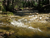 It was then that I came to the ford. Lots of late snowmelt means good waterfall action into July, and it also means that the ford was two to three feet of fast-moving water. At first, I wasn’t sure where I was; it took a consult with my compass and several looks at the map to realize that the teensy blue line on the map was this dangerous-looking pour of water.
One of my survival skills is having a reasonable assessment of what I can do. I was just not ready to make this crossing, not by myself (where were the crowds now?), so I started backtracking. With the bushwhacking and the pondering, I had lost a lot of time, and I didn’t see a way to continue the loop. I would have to return the way I came, along some well-traveled trail.
My other survival skill is stubbornness. I got back to the southside road, and realized that I could still make the loop and the 18:00 shuttle if I beat feet along the road to the Pohono Bridge.
I made the turn at the bridge and started the return along the north side of the valley. Have I mentioned how profligate the scenery is around here? There you are, walking along, then there’s a break in the canopy and WHOMMP! there’s El Capitan looking at you.
I got to the northside road… and no picnic area. So I crossed the road and continued east. Lovely meadows, but no picnic area. Well, the last mile is always the longest, right? Somewhere just shy of 18:00 I realized that I had misread trail and map again, and that I had overshot the picnic area. I calculated that I could turn around and make a westward dash for the picnic area and the last El Cap shuttle, or I could continue east to Camp 4 where I could catch a Valley shuttle at the westernmost point of its route. After hiking 6 miles (and a climb in the morning), I wasn’t ready to outrun a bus. So I headed for Camp 4, adding another 2 miles or so to the walk. Total time for the open-jaw walk: approx. 3:30.
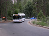 A busman’s holiday: waiting for the bus to arrive.
I did pause long enough to look at what I keyed out as a female Black-headed Grosbeak (Pheuticus melanocephalus).
Back in Mariposa in the evening, many of the eateries roll the sidewalks up by 21:00, but I had a fine dinner at The Butterfly Cafe. This place can even make a house salad interesting.