- A new niche scam: Someone has been impersonating Robert Faturechi, ProPublica reporter.
- A recap of rumors and misconceptions about the “missing” Georgetown Metro station, from the guy who wrote the book.
Did planners consider a rapid transit station for Georgetown?
Yes, but only in 1962 and 1963.
- Mid-century Malibu in paper matchbooks: I especially love the map to the Lindomar Lodge Motor Hotel printed on the inside of the matchbook cover. Some of the 50s gags are rather sexist, alas.
- From Mark Liberman of Language Log and Clare Downham, a poster of UK regional names for alleyways. Lemony Snicket revealed. I’m idly working on something about American practice of double-naming thoroughfares, like Street Road in Bensalem, Pa. and elsewhere.
Category: Golden State
A mystery: 11: solved
Thanks to Cameron Binkley and his librarian contacts at the California Academy of Sciences, I now have confirmation that Laura White’s memorial to her husband, as specified in her will, was indeed realized at CAS. According to academy’s 1958 annual report, the Lovell White Hall of Man and Nature was part of the Hall of Science (along with the Alexander Morrison Planetarium).
The Whites’ daughter-in-law Ruth gave an oral history interview in 1976. She fills in some of the details of the White-CAS connection.
RB: So then I gave [the Garden of Allah] to the California Academy of Sciences and they had it for about three years, two or three years and they loved it. The reason I selected that to give it to is because the California Academy of Sciences has a memorial for Ralston’s father, Mr. Lovell White. His mother gave it to the California a memorial there, so I thought it would be very appropriate for the —
CE: The Academy of Sciences. Were they delighted with the bequest?
RB: They certainly were delighted but regrettably their income was restricted to be spent in the City and County of San Francisco so they had to give it up painfully.
A mystery inside a mystery: The Garden of Allah, Ralston and Ruth’s Marin County home, is not the Los Angeles resort of the same name that is the setting for Scott and Hem in the Garden of Allah.
The Hall of Science was demolished as part of CAS’s rebuild in 2008, so maybe Laura and Lovell would have been better off with a plaque or a statue.
Some links: 79
And two pieces about what’s happening with water in the West:
- Luke Runyon checks in with a water district in Colorado that has imposed water taxes on itself, lest the aquifer that it depends on run dry.
- Dale Kasler and Ryan Sabalow report from Sacramento: New Deal-era water decisions threaten to clobber a massive rework of an aging water distribution network. A map by Sharon Okada, with four different colors to represent stakeholders, lays out how messy this problem is.
Py-we-ack
 A few days ago, I was flipping back through my posts from my California trip in 2011, including notes I made at Tenaya Lake. In today’s paper, Daniel Duane explains how it got that name, and the story isn’t pretty.
… Tenaya Lake — a place so important to me that I want my ashes scattered there — is named not in honor of Tenaya but in joyous celebration of the destruction of his people.
A mystery: 11
In the course of researching the life of Laura Lyon White (Mrs. Lovell White), I came across an interesting turn of events concerning LLW’s estate.
Laura’s husband, Lovell, a banker, died in 1910. Laura died in 1916. Their one surviving son, Ralston, married Ruth Boericke. The terms of Laura’s will specified that, if Ralston and Ruth had no children, a third of the estate was to be held in trust by the Savings Union Bank and Trust Company, later the American Trust Company, to build a monument to Lovell “typical of banking development in the State of California”. This provision seemed reasonable enough in the prosperous years before 1929. However, Ralston and Ruth’s financial circumstances declined during the Great Depression. Thus, when Ralston died in 1943, at his urging, Ruth contested the provision for the memorial.
Ruth lost her case, as far as I can determine, in a appellate court decision handed down in 1945. But if so, American Trust should have erected something. Yet I can find no evidence that a monument was built. I’ve written to a couple of knowledgeable sources, but so far have found no plaques or statues.
Now, in the old California Academy of Sciences, there once was a Lovell White Hall of Man and Nature. It was so designated by 1953, and still went by the name Lovell White Hall in 1986. The original Earthquake Theater was installed there. But Lovell White Hall would have come down in the 2008 rebuild; there is no such place in today’s California Academy of Sciences.
Did LLW’s money go to the CAS? I’m still following some leads.
Plunging
Oh, one more from the links pile: a gorgeously illustrated post by Scott K. Johnson about the geology of California’s Sierra Nevada. Is the mountain range rising or falling? We still don’t really know.
That might disappoint people who just want a simple answer, but messy fields of research are interesting fields of research. As Greg Stock [geologist for Yosemite National Park] described it, “Part of what’s been fun about being involved in this issue of Sierra uplift, for a couple of decades now, is that every so often—actually pretty often—a paper will come out that really challenges a lot of what we thought we had accepted before. Even though I know it’s a little frustrating for our interpreter rangers here [at Yosemite], who kind of want a nice clean story to tell the public, I have to tell them—no, no, this is great, because this is the way science works. And it’s a great thing to be involved in a field of study that is this turbulent.”
Bibbity Dum-dum
A lovely simile linking the cinematic, literary, and pictorial worlds, from Anthony Lane’s review of P. T. Anderson’s adaptation of Thomas Pynchon’s Inherent Vice:
As a lyricist of California light, Pynchon is rivalled only by Richard Diebenkorn, who spent some twenty years painting his Ocean Park series in Santa Monica, and I doubt whether any director—dead or alive, Altman or Anderson—could really conjure a style to match the long surge of a Pynchon sentence as it rolls inexhaustibly onward.
Cinclus mexicanus
This isn’t exactly a lifelook, in the sense that Frank Izaguirre is promoting. But it was my first sighting of this species, it was a good look, and it’s been one of the most personally significant. When people ask me, “what is the best bird you’ve seen?” this is usually the story I tell.
In December 1996 I was visiting family in Sacramento and doing some of my first birding in California. I was fortunate in that the rains that had been pounding wine country let up just before I arrived, so I had some good birds in the Central Valley—my first Sandhill Cranes, for instance. But the lowland rains meant substantial snow cover in the mountains. U.S. 50 was closed, preventing me from getting out to explore at elevation.
Finally, on the morning of Christmas Day, the roads were opened, and I made a dash to the Eldorado National Forest to see some birds before rejoining family for the holiday. I was pretty much limited to finding a parking place on the side of the road, clumping through someone else’s tracks in the snow (three to five feet of it on the ground) for a hundred yards or so, then returning to the car.
Looking at my checklist for the day, I see that I didn’t record much: some juncos, nuthatches, maybe a kinglet. The White-headed Woodpecker was a lifer for me. But it’s when I stopped on a footbridge over a little creek that the Look happened.
I was watching the meltwater rushing downstream, and I noticed a burbling, roiling something under the surface of the water. Just water over the rocks, right?—but then the roiling moved. What, a tiny mammal? I thought. The disturbance continued moving upstream, and then the dark head of a bird broke the surface. The rest of the bird emerged, the size of a thrush or smaller. It was an American Dipper (Cinclus mexicanus), a/k/a Water Ouzel, doing what it does best, foraging in fast-moving mountain streams. The bird worked the stream a bit more, then took flight, settled in a tree, and sang its whistling, trilling song.
And thus, #227 on my life list.
Nice work
Malcolm Kenton speaks for the beavers.
Beaver ponds attract and sustain other wetland-dependent creatures—such as turtles, herons, otters, ducks, and many types of birds and fish. They also do a good job of retaining stormwater runoff, allowing pollutants to settle out before the water moves downstream. Beavers have also become a unique cultural asset to cities and towns: they are local celebrities in places like the Bronx River in New York and Chicago’s Lincoln Park.
But perhaps the best-known “downtown beaver” success story comes from Martinez, California, a Bay Area city that rehabilitated part of the creek that runs through the center of town. When a beaver colony established itself there in 2008, the local government threatened to have them removed. But citizens’ organization Worth a Dam rose to the creatures’ defense, and the city has come to celebrate its newfound furry, feathered and finned denizens…
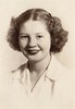
Pics of Mom
I’ve been going through her old scrapbooks looking for interesting images of my mother. Her treatment of her prints was far from archival, so there’s a lot of noise in the scanned images.
 The tasteful sepia-toned photo was likely made for her high school yearbook. The soft gradient effect as the folds of her blouse shade into the background is something we haven’t seen for decades.
 This was her last Christmas on her own before she was married. The sky’s the limit.
 This one is from 1983, with her father and sister-in-law. I’m not sure where it was taken; the background looks North Carolina-ish.
Methuselah lived more than 900 years
Great photographs by Domingo Milella of a grove of Great Basin Bristlecone Pine (Pinus longaeva) in California’s White Mountains.
Yosemite National Park and Mono Basin: 6
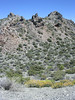
The first thing to know about visiting Bodie State Historic Park is to plan extra time, both because this busted gold mining town is much bigger than you would expect and because the drive in will take more time than you’ve planned for. At first, I planned on driving in on Cottonwood Canyon Road from CA 167, but a sign promised “very rough road” and the prospect of covering 10 miles in 30 minutes. I had abused my rental enough already, so I backtracked to U.S. 395 and CA 270.
The good news about CA 270 is that the Caltrans has an active repaving project for the state highway-numbered section of the road. This is also the bad news, because you will sit for a good period of time waiting for a pilot car to escort you through the one-lane work zone. The bad news is that, once you get out of the work zone, the pavement is very rough in multiple patches. The bad bad news is that CA 270 only designates the first ten miles of the road into Bodie: the last three miles lose the highway number and the pavement.
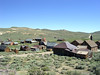 What strikes me about Bodie is that it comes from an era where land was cheap and sanitation was not. There is a lot of empty space between buildings (although the interpretive brochure, $2 at the entrance station and a bargain, says that only a small fraction of the town’s original buildings are standing). Nevertheless, I noticed that only the hydro plant and the firehouse are located close to Bodie Creek—good idea to give the freshwater supply plenty of room. Very few buildings are two stories, not even all of the hotels. However, the schoolhouse has two floors. And the buildings are not crowded together, beetling over one main street, like they would be in a Hollywood movie set.
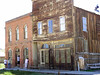
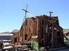 There is a museum to tour, and when we look in the windows of some of the structures, we see some artifacts have been positioned to give us the sense that someone might still be living here. But the dusty roads and the whine of the high mountain (elevation 8,379 feet) wind in the wires are authentic. Since most of the structures are wood, and built all at about the same time (the town housed about 10,000 people in 1879), most of the structures are at the same state of crumble. There are some brick structures (like the post office in the left image, and the remains of the vault for the first bank). The sawmill (right image) is one of the more decrepit buildings.
 The mill area (the gray-blue structures at the left of the image) is off-limits to casual touring, but I did see a guide leading small groups through it.
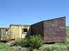 The interpretive brochure simply describes this as Dog-face George’s house. It’s on Green Street, on the way out of town up the ridge heading southeast. Too bad we don’t know more of George’s story, but at least his nickname and his house are remembered.
Bonus birding: a couple of looks at Sage Thrasher (Oreoscoptes montanus) on the drive out of town back to U.S. 395.
Yosemite National Park and Mono Basin: 5
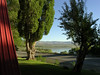 My semi-rustic accommodations near the western short of Mono Lake (no phone, TV, A/C, internet) were pleasant enough, save for the regular noise of heavy truck traffic on U.S. 395, just a few meters from the cabin.
 I started the morning on the north side of the lake, at the county park. Very pleasant: a clear sky; shirtsleeves rolled down; save for one other photographer, I had the place to myself. A scope would have been a helpful to get a better view of the phalaropes feeding, but it wasn’t essential. In late July, the birds are almost all out of breeding plumage, so I was using field marks like bill length to separate Wilson’s from Red-neckeds. The short boardwalk trail leads straight out to the lake, with no loop. Some up-close encounters with the tufa, described by someone as a petrified spring.
 As compared to the interpretive signage on the federal property on the south side of the lake, the county is more explicit about the role of the City of Los Angeles in the depletion of Mono’s water. The lake itself is not the water source; it has no outlet and is too salty for drinking. (That Mad King Ludwig calcium carbonate geology didn’t happen overnight in the 20th century.) Rather, it is the diversion of water from the Owens River and elsewhere in the watershed that is causing the lake to dry up.
 In case we needed reminding, the city still owns land and water rights here. Forget it, Jake. It’s Chinatown.
 Following a tip from the Westrichs’ book, I followed an unmarked section of Cemetery Road that became gravel, beyond the boneyard, to a place marked by a shack, where Yellow-headed Blackbirds once congregated. No more. But I did learn something useful: car birding in a hybrid is brilliant! I was rumbling along the gravel, slow enough that I was already in electric mode, when I saw a bird I wanted a better look at. I touched the brake, the car stopped—and everything went quiet. No idling noise, no vibration. Just quiet.
 On the south side of the lake, on Forest Service land, the trail forms a loop and you can get right to the water, if you care to. (It feels a little oily, or like watery gelatine.) There are consequently a lot more people. On the plus side, the sun angle is much better for looking at the birds. One or two of the Red-necked Phalaropes bore some traces of breeding plumage. Along with the signature spinning strategy, the birds seem to herd the alkali flies up to the shoreline for easier snacking. No vertebrate life survives in the water, but along the with flies, the lake is home to an endemic brine shrimp, Artemia monica.
 Undisturbed, the flies form thick clusters. But the shadow of a slow hand wave is enough to get them moving.
 I left the lake, tried another birding stop that might have been great at publication time (1991), then paid a short visit to Panum Crater. The volcanoes here in the basin are dormant; it is estimated that Panum was active only 650 years ago. Shards of obsidian on the trail. I didn’t walk the entire loop of the crater rim: hot, dry, not too many other visitors, and I really couldn’t be sure that the sketchily-marked trail made the complete circuit. Ever so slowly, the veg is making a place for life in the volcano’s crater.
Yosemite National Park and Mono Basin: 4
Sunday was intended for driving and birding, but I did as much botanizing as I did birding, and that without a local field guide. I drove east over the mountains along the road to Tioga Pass, which was not cleared of snow and opened to traffic until June 18 this year. I used LoLo and Jim Westrich’s Birder’s Guide to Northern California and Jean Richmond’s Birding Northern California as guides.
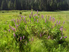
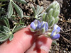
 At Hodgdon Meadow (4,900 feet), I heard a few difficult flycatchers but saw few birds. At the campground, smoke was still evident in the air from a managed burn a couple weeks previous. I saw a lot of this lupine, perhaps Lupinus grayi.
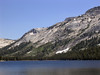
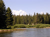
 At Olmstead Point, I couldn’t even scare up a Clark’s Nutcracker. Tenaya Lake is beautiful, but wasn’t birdy when I visited mid-day.
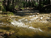
 At Tuolumne Meadows, the bird that surprised me was Spotted Sandpiper (Actitis macularia), working the banks of the river.
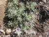
 On a side trail from the meadow, I found this fuzzy congener of the lupine I saw at lower elevations. I believe this to be Lupinus breweri. It was doing a scrappy job of colonizing otherwise bare soil; pines were the only other veg in evidence.
A final stop at Dana Meadows (about 9,700 feet) yielded a distant look at a Cassin’s Finch (Carpodacus cassinii). I got a good look at the strong red crown contrasting with the rest of the head feathers.
I left the park at Tioga Pass, just shy of 10,000 feet, and dropped down into the Mono Basin via Lee Vining Canyon.
Yosemite National Park and Mono Basin: 3
One of the best ways to get around Yosemite National Park, I quickly figured out, is to hop one of the shuttle buses that work the valley. Shuttle to your trailhead, walk a circuit or a straight line, and get back to your car at the central parking area on another shuttle. This plan is not without pitfalls, however, as I learned.
Saturday afternoon, after climbing to Columbia Rock in the morning, my plan was to use the El Capitan shuttle to its stop at the bridge over the Merced, hike the western loop of the Valley Floor Trail, then catch the El Cap shuttle at the picnic area and return to my rental vehicle. Now the Valley shuttle (the green route) runs into the evening, serving the campgrounds, the lodge, and suchlike; but the El Cap shuttle (the burgundy route) only runs until 18:00. No problem, I was on the trail by 14:45, the loop was about 6 miles on mostly level ground (rated moderate by Ranger Mates only for its length), I should be back to catch the last shuttle easily.
As soon as I left the shuttle stop, I discovered a hard truth about hiking in the park: the park doesn’t believe in trail blazes, and it’s not too keen on lots of wayfinding signs. I missed the trail I wanted to follow and was immediately backtracking along the road. (I’d like to turn the PATC loose in this park.)
Confidential to the man of the couple who asked me for directions to Half Dome on this same road: in casual conversation with a stranger, to make a point about gender roles, it’s best to avoid references to the Jaycee Dugard abduction case.
I found the trail I was looking for and started moving. It turns out that the Valley Floor Trail is not a good choice for a sunny July afternoon. It touches the very busy roads at too many points, and is generally too full of people. What is nice about the trail is that it’s nearly flat and smooth—the trail is worn-out pavement in a few places.
I was still making good time, looking to make the turn at the Pohono Bridge at sometime after 4. In the section leading to the bridge, the trail crosses the southside road, fords some braided streams, then skims along the Merced. I crossed the road and promptly found myself off trail; maybe I was disconcerted by the huge idling bus I had to walk around at the road crossing. But since I could keep the river on my right and the road on my left, I figured a little bushwhacking wouldn’t kill me.
 It was then that I came to the ford. Lots of late snowmelt means good waterfall action into July, and it also means that the ford was two to three feet of fast-moving water. At first, I wasn’t sure where I was; it took a consult with my compass and several looks at the map to realize that the teensy blue line on the map was this dangerous-looking pour of water.
One of my survival skills is having a reasonable assessment of what I can do. I was just not ready to make this crossing, not by myself (where were the crowds now?), so I started backtracking. With the bushwhacking and the pondering, I had lost a lot of time, and I didn’t see a way to continue the loop. I would have to return the way I came, along some well-traveled trail.
My other survival skill is stubbornness. I got back to the southside road, and realized that I could still make the loop and the 18:00 shuttle if I beat feet along the road to the Pohono Bridge.
I made the turn at the bridge and started the return along the north side of the valley. Have I mentioned how profligate the scenery is around here? There you are, walking along, then there’s a break in the canopy and WHOMMP! there’s El Capitan looking at you.
I got to the northside road… and no picnic area. So I crossed the road and continued east. Lovely meadows, but no picnic area. Well, the last mile is always the longest, right? Somewhere just shy of 18:00 I realized that I had misread trail and map again, and that I had overshot the picnic area. I calculated that I could turn around and make a westward dash for the picnic area and the last El Cap shuttle, or I could continue east to Camp 4 where I could catch a Valley shuttle at the westernmost point of its route. After hiking 6 miles (and a climb in the morning), I wasn’t ready to outrun a bus. So I headed for Camp 4, adding another 2 miles or so to the walk. Total time for the open-jaw walk: approx. 3:30.
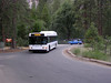 A busman’s holiday: waiting for the bus to arrive.
I did pause long enough to look at what I keyed out as a female Black-headed Grosbeak (Pheuticus melanocephalus).
Back in Mariposa in the evening, many of the eateries roll the sidewalks up by 21:00, but I had a fine dinner at The Butterfly Cafe. This place can even make a house salad interesting.