 Skunk Cabbage (Symplocarpus foetidus) is emerging from the wet spots along the Glade in Reston. The streaks of claret on the new growth are a nice surprise.
Category: In the Field
My year in hikes and field trips, 2011
The Texas festival put lots of birds on my life list, while the California jaunt introduced me to some stunning water features.
- January’s first spikes of Skunk Cabbage on Sugarloaf Mountain
- Hemlock Overlook Regional Park, Fairfax County, Va.
- urban redevelopment in the Silver Spring, Md. CBD
- making the 2011 Great Backyard Bird Count
- stormwater management in the headwaters of Piney Branch, Montgomery County, Md.
- spring wildflowers at the Glade, Turkey Run Park, Governor Bridge Natural Area, Violette’s Lock, Thomson WMA, and Sugarloaf Mountain
- butterflies in Montgomery County and the Frederick City watershed
- Yosemite National Park and Mono Basin: 1, 2, 3, 4, 5, 6
- grasses at Great Falls Park, Fairfax County, Va.
- Bull Run Mountains, Prince William/Fauquier Counties, Va.
- Bristoe Station Battlefield Heritage Park, Prince William County, Va.
- Fort Totten and Congress Heights walking tours, Washington, D.C.
- Rose River loop, Shenandoah NP
- botany in Little Bennett Regional Park, Montgomery County, Md.
- Rio Grande Valley Birding Festival: 1, 2, 3, 4, 5
- winter weeds at Woodend Sanctuary, Chevy Chase, Md.
- and, as every year, Huntley Meadows Park, Fairfax County, Va.
RGVBF 2011: 5
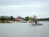
 We wrapped up the Rio Grande Valley Birding Festival with a bang, visiting the South Padre Island area. The resort area on this barrier island is, um, more built up than its counterparts in, say, North Carolina. Nevertheless, there are some protected green spots that serve as migrant traps and places for wildlife to overwinter. And SPI seems to be much less popular this time of the year than it is at spring break; we saw lots of deeply discounted accommodations on offer.
Kevin Karlson led this trip, and even he was knocked over by what was probably the best bird of the festival, a Long-eared Owl (Asio otus) that turned up in the greenery behind the convention center. The flats on the lagoon were also good for Royal and Sandwich Terns (Sterna maxima and S. sandvicensis).
 A boat trip, leaving from Port Isabel in view of the lighthouse, provided good looks at Franklin’s Gull (Larus pipxcan).
Back at the festival HQ in Harlingen, I finally stopped to look at a large flock of black birds in the city park and found what everyone had been saying was easy to find. Mixed in with the Great-tailed Grackles (Quiscalus mexicanus) were 30 to 40 Bronzed Cowbirds (Molothrus aeneus).
I had a great four-plus-day visit through a good variety of habitats, with a trip list count of 125. Yet I left a good number of birds on the table for my next trip to south Texas. (I’m looking at you, Ladder-backed Woodpecker.)
RGVBF 2011: 4
Justin Rink led Friday’s field trip to the upper Rio Grande Valley, with stops at the town of Salineño and Falcon State Park, near the line between Starr and Zapata Counties.
 The morning was brisk along the river. Starr County is an upland relative to the bottoms of Brownsville and Harlingen. I regretted leaving my sports gloves behind in Reston as I lugged the cold tubes of the tripod about. But we had nice looks at several birds, including A-quality views of Lincoln’s Sparrow (Melospiza lincolnii) and Pyrrhuloxia (Cardinalis sinuatus). We looked at two of the three valley speciality orioles, Altamira and Audubon’s; seen across the water, these birds are the first for my Mexico list.
 At the county park, some of my busmates spotted Greater Roadrunner, but I was content with multiple looks at Cactus Wren (Campylorhynchus brunneicapillus) (a big eight-inch wren warrants a big scientific name) and Lark Sparrow (Chondestes grammacus).
Back at home base in the afternoon, I followed tips from the festival guide and my seatmate to pick up Black-bellied Whistling Duck (Dendrocygna autumnalis) at the Harlingen Country Club (20+ of them) and Green Parakeet (Aratinga holochlora) on the wires above the intersection of Dove Avenue and 10th Street in McAllen (holy Michael J. Fox, more birds than I could sort through).
RGVBF 2011: 3
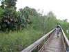
Thursday’s morning field trip left the afternoon free, so I followed the advice of the festival brochure/checklist and sauntered over to Hugh Ramsey Nature Park in Harlingen, a “99% guaranteed” spot for Buff-bellied Hummingbird (Amazilia yucatanensis). I got good looks at this target bird, both immatures and adults. The park, wedged between Harrison Avenue and the Arroyo Colorado, features numerous plantings of native flora (with interpretive markers) and feeder setups, both of which do a good job of attracting native fauna.
 Many stretches of the lower arroyo trail are overgrown, and the numerous social trails and occasional trash mark this sector as a party stop. Blue-gray Gnatcatchers (Polioptila caerulea) wheeze their songs, providing some competition for the steady drone of traffic on Loop 499.
 Wildflowers keep the lepidopterans happy, like these two Queen butterflies (Danaus gilippus). Odonates are also active even this late in the year.
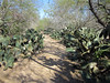
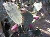 On the upper slopes of the park, north of the parking area, sunnier conditions prevail, supporting this impressive patch of prickly pear cactus. This is Cactus Apple (Opuntia engelmannii); some of the plants are in fruit. Rodents skulk beneath the cactus’ protective lobes.
 The hummingbird feeders are positioned in conjunction with plantings of Turk’s Cap (Malvaviscus arboreus), the local hibiscus that provides nectar for the hummers. A deck with benches is situated with the blooms at eye-level.
At a platform feeder, a thuggish group of House Sparrows stationed lookouts as they chowed down; they were soon evicted by a Long-billed Thrasher (Toxostoma longirostre).
 As the sun settled toward the horizon, a herd of eight or more Plain Chachalacas (Ortalis vetula) assembled, ready to make their own lumbering run at the feeder. I have never seen a more bovine member of class Aves.
The park is an absolute gem. I regret that I didn’t have more time to return and explore it more.
RGVBF 2011: 2

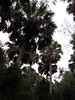 We rolled down Texas 511 south of Brownsville, past the port, through the checkerboard of residential properties, scrapyards, auto repair shops, and trucking establishments; crossed the red palings that comprise a section of the incomplete barrier between the two countries; and entered the Sabal Palm Sanctuary. The 500-acre property includes one the last vestiges of original Rio Grande Palmetto (Sabal mexicanus), also known variously as Sabal Palm or Mexican Cabbage Palm. Our guide David Benn pointed out a key ID characteristic: the edges of the petiole on most palms you see in Texas (most of them introduced) is toothed, but in the Sabal Palm it’s smooth. As the tree grows taller, eventually the dead leaves along the trunk (the “boots”) drop off.
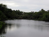 Oh, and the birding was good, too. The day started wet and chilly, so we hunkered down in a semi-blind at the edge of an artificially-maintained resaca, an oxbow lake that was once a loop of the rio. Lots of ducks to look at, and I got my first good view (of many to come) of Great Kiskadee (Pitangus sulphuratus).
 In the uplands, Black-crested Titmice (Baeolophus atricristatus) made our acquaintance, and we found more of that gluey Texas mud; back at the visitor center where a feeder is set up, an Olive Sparrow (Arremonops rufivirgatus) broke out of its skulk to become identifiably visible.
RGVBF 2011: 1
My first field trip at last week’s Rio Grande Valley Birding Festival was led by Bill Clark, and our targets were raptors of the valley. Bill did not disappoint, and I checked off fourteen raptor and scavenger species that day, including four lifers and several good +1 sightings.
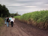 We began at the Cannon Road tract in Hidalgo County, where we found sugarcane fields prepared for harvesting. A firebreak is raked into the road surrounding the field, and then the chaff is burned off the field before the cane is cut. Burning the field flushes small rodents and lizards, and the local raptors tuck in like they’re at Golden Corral when a new tray of meatballs has just arrived.
Looking at this image, you can also get a feel for the consistency of south Texas soils. The hardpan is locally known as caliche; when it gets the least bit of moisture (a line of rain had blown through on Tuesday evening) it turns into some of the stickiest gumbo I’ve ever encountered. (On my last morning in town, I blundered into a wettish patch; I left a track of dried mud through the airport, into the aircraft, and finally left most of it at the curb at BWI.)
 We got back on the road, and stopped at a recently burned cane field along U.S. 281 to watch the bird life on display. We moved on to Anzalduas Park, located on the Rio Grande River. There is a small companion park in Tamaulipas state across the border. Due to the river’s meanders, this is one of the places where you can look due north into Mexico.
 At Anzalduas and every other venue along the river, the apparatus of the Border Patrol was in blatant evidence. We got to know the green-striped white SUVs quite well.
Fortunately, the birding was quite good. Although we missed our target Gray Hawks, I saw my first Green Jays (Cyanocroax yncas)—first of quite a few for the trip.
We then bolted southwest down the highway into Cameron County for a couple of spots that Bill knew to be reliable for Aplomado Falcon (Falco femoralis), the lead-colored falcon. Extirpated in the northern part of its breeding range, the bird is being reintroduced into south Texas via captive breeding.
Up and down Texas 100, we passed Bobz World, the Lone Star’s answer to South of the Border. Like the web site says, you gotta see it to believe it.
Sooner or later, we all go through it

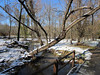
 The Dalecarlia Tunnel carries the Capital Crescent Trail under MacArthur Boulevard in southwest Montgomery County, close to the District line. Built in 1910, the 341-foot long tunnel originally carried a spur of the Baltimore & Ohio Railroad.
Little Bennett Regional Park: botany foray
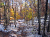
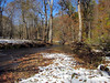 Yesterday’s unexpected snow and ice caused trip leader Carole Bergman to simplify this morning’s field trip to Little Bennett Regional Park, lest we go slip-sliding away. We ended up following the track of the old Hyattstown Mill Road, from Clarksburg Road along Little Bennett Creek as far as the creek ford. I have visited the park a couple times last year, but this is the first time I’ve spent an appreciable amount of daylight time north of the creek.
Bird activity was surprisingly lively. We found a few Eastern Bluebirds at the woodcock clearing, and a Ruby-crowned Kinglet (Regulus calendula) farther down the trail.
 But the main objective of this trip was fall/winter trees. As the sky cleared and the snow melted, the canopy dropped slush bombs on the group, but we soldiered on. Carole pointed out generous examples of Post Oak (Quercus stellata), some huge old Black Willows (Salix nigra) in a creek bottom, Carpinus caroliniana in fruit (nuts protected by involucral bracts), Witch-hazel in flower.
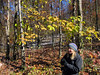
 Special trees for the trip: Fringetree (Chionanthus virginicus), in the image at left, with Carole in the foreground, and a solitary shrub of Bear Oak (Q. ilicifolia), in the image at right. Harlow writes, “Seton [The Forester’s Manual, 1912] says it was called bear oak because this animal was about the only one that would eat its intensely bitter acorns.”
 On the way back to the rendezvous point, we took a side trip to the Burnt Hill parking area in the extreme northeast edge of the park to find a small patch of American Chestnut (Castanea dentata). The trees are protected with exclosures, lest hungry deer munch every last bit of green sprout from these desperately regenerating trees. One of the three we looked at had a limb bearing leaves (now yellow) and a few fruits. But the real value of these trees is in their genetics. American Chestnut Foundation breeders have collected pollen from these individuals, in their attempts to raise strains that are resistant to blight.
At the park: 45
Some late-season nesting activity led to some late-season recordkeeping, so here we are in October with final results for the spring nesting season of Hooded Merganser and Wood Duck at Huntley Meadows Park.
We took five boxes down that had not seen nesting activity for five years or more.
This was another year that was not kind to the Wood Ducks, with a 5-year-low 37 ducklings fledged. We saw five mixed-clutch nests this year, out of a total thirteen clutches. Perhaps we are getting better at distinguishing the two species’ eggs.
Summary numbers: 51 hatched/76 laid Hooded Merganser, 37 hatched/82 laid Wood Duck. This year’s raw data worksheet and the 30-year historical summary are available.
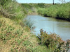
Rose River loop
 Feeling the need to walk along fast-moving mountain water, I plotted a coathanger circuit hike using the Dark Hollow Falls and Rose River Trails in Shenandoah National Park, following only blue and yellow blazes—no white. The trails in this area offer quick access to a couple of fine water features.
 A nice wash of fall color was on display, the reds provided primarily by maples. The Dark Hollow Falls Trail is built for lots of traffic, and it’s very popular. It’s a little less popular with the Bambi-peepers who are making the 600-foot return climb from the falls back to the parking lot.
Walkers become more scarce below the falls, where the descending trail follows Hogcamp Branch to its junction with the Rose River. Some muddy downslopes made me glad that I am carrying my stick with me on a more regular basis. I didn’t spend a lot of time botanizing, but I did find a little patch of Partridgeberry with some fruits still remaining. A couple of Downy Woodpeckers, a Common Raven to break up the quiet. On the return climb, a mixed flock with Dark-eyed Juncos.
 For a return leg, I like the fire road, rather than the recommended horse trail on the other side of Skyline Drive. This way, I can stop at the Cave family cemetery to pay my respects.
Elevation change 1200 feet, distance 5+ miles, a fairly easy 3:20.
Congress Heights
Nathan Harrington led my afternoon WalkingTown DC tour, a scamper through the neighborhoods of Congress Heights. Nathan didn’t have a wealth of heritage markers or quirky landmarks to pause for, and we covered a lot of ground, but the tour was quite enjoyable.
Colonial period settlers used this land as tobacco plantations, but became victims of their success: runoff from the farms silted up the Anacostia River, rendering it no longer suitable for shipping. (Early Bladensburg, upstream, served ocean-going boats until the river filled in.) Later, freedmen like Tobias Henson owned property.
In the late nineteenth century, the heights were put to use as cemeteries for the Jewish community; walking east along Alabama Avenue S.E. from the Congress Heights Metro station, we passed these places of rest. We also passed Malcolm X Elementary School, which provides a STEM curriculum.
 Doubling back and making our way to the small commercial district at the intersection of Martin Luther King Jr. and Malcolm X Avenues S.E., I noticed numerous street trees that resembled Willow Oak (Quercus phellos), but these trees sported very bristly caps to their acorns. A cultivar? A mimic thrush also made its presence known. Nathan’s not sure why this particular intersection warrants the “formerly” signage: the street has been named for Malcolm X for at least fifteen years.
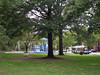 Unfortunately, dining options in Congress Heights are limited. Nathan mentioned the IHOP (franchised to a group of D.C. policemen) to the east, one of the few sit-down restaurants in Ward 8. But the neighborhoods are leafy, and this bit of green extending from Shepherd Parkway is attractive. (Not too many neighborhood folks out today, on this unseasonably cool and wet Sunday.)

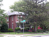 In the late nineteenth century, Arthur Randle converted about 48 acres of the Knox farm for residential property. The name “Congress Heights” was chosen through a promotional contest, and is typical realtor hyperbole: you can’t actually see the Capitol dome from any ground-level Congress Heights location. Most of today’s residences were built later, in the early to mid-twentieth century. Nathan’s home on 11th Place S.E. (where he treated us to post-tour coffee and superlative banana bread) is a Craftsman bungalow from 1925. Many of the houses of these working- and middle-class neighborhoods are quite spruced up, although security dogs and alarm systems are all too necessary. Certain of the blocks remind me of Archie Bunker’s Hauser Street in Queens. The area holds attractions for would-be homeowners in the District: prices are much lower than west of the Anacostia, and parking is easy-peasy.
 Local landmark Congress Heights School is back in the education business, now as a charter school.
 True to the neighborhood’s mid-century history, fallout shelter signs can still be found. I spotted two for my collection: one at 5th and Mellon Streets S.E., and this one at Brothers and Highview Places S.E.
Further reading: The Advoc8te’s Congress Heights on the Rise; John R. Wennersten, Anacostia: The Death and Life of an American River (2008).
Fort Totten
 My first of two walks under the auspices of WalkingTown DC was a quick spin through Fort Totten led by Mary Pat Rowan, with an emphasis on the woody plants of this semi-preserved area. The geology of this high point in the landscape is somewhat unusual: it’s a gravel terrace perched on impermeable clay. You can get a bit of the feel for the geology in the image, where the clay and gravel are exposed by excavations that provided a powder magazine for this Civil War earthworks in defense of the capital. Unusual geology means unusual flora, with some dry conditions specialists in evidence, among them Amelanchier species (one of these days I will learn to recognize Serviceberry) and Blackjack Oak (Quercus marilandica). Chestnut Oak (Q. montana), that upper-elevation specialist, is also thriving. Mary Pat also noted that Pitch Pine (Pinus rigida) can be found in the park, but we didn’t have time to take a look.
Barreling off trail and kicking up occasional human-dropped litter, Mary Pat led us through a patch of heath community plants, including high and lowbush blueberries (Vaccinium sp.), huckleberries (Gaylussacia sp.), and Pink Azalea (Rhododendron periclymenoides).
Bristoe Station Battlefield Heritage Park
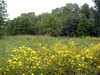
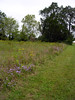 A meadow in early fall means a goldenrod clinic for the experienced, but I shied away from genus Solidago and concentrated on the easier plants. Charles Smith ably led a VNPS field trip to Bristoe Station Battlefield Heritage Park, which features more than 100 acres of upland that are being restored to meadow. (The park is so new that it doesn’t register on Yahoo! Maps.) A field of fescue aside, the place looks pretty good (especially compared to another old field that I have visited recently).
The country around Bristoe (or Bristow) Station, on the railway line that connects Manassas to the Virginia hinterlands to the southwest, was the site of Civil War battles in 1862 and 1863. The line is still in heavy use (we heard freights come through about once an hour), and Bristow is just beyond the Broad Run terminus of VRE commuter service. Some of us complained about noise from the general aviation airport nearby. No two ways about it, this park is wedged in close to the built environment of exurbia and its housing subdivisions. According to a trailside map, the park also lies in the headwaters of the Broad Run watershed.
 Charles (who is part of Fairfax County’s Resource Management team), along with field trip participants who volunteer at Fairfax County’s Huntley Meadows Park, was a good source of peripheral resource management information and opinions. He calls the alien grass Arthraxon hispidus “the Microstegium of wet, open places.” Apparently the county champion Winged Sumac (Rhus copallinum) can be found in Huntley Meadows Park. Charles encouraged us to get a whiff of the maple syrup-scented Sweet Everlasting (Pseudognaphalium obtusifolium); pointed out the cunning fruits of Seedbox (Ludwigia alternifolia); and found a loosestrife with the hard-to-spell name Cuphea petiolata, otherwise known as Blue Waxweed. Charles does birds, too, and he reports that Grasshopper Sparrow (Ammodramus savannarum) is uncommonly cooperative in this patch—worth a return trip.
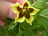
 Others in the group found several examples of a Ground Cherry in flower and fruit that we consensus ID’d as Smooth Ground Cherry. USDA gives the nomenclature as Physalis longifolia Nutt. var. subglabrata (Mack. & Bush) Cronquist. The ornamental plant Chinese Lantern is in the same genus.
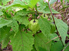
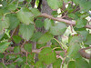 No fruits, but a native Red Mulberry (Morus rubra) was doing well (the common White Mulberries [M. alba] you see everywhere were imported by colonists in a failed attempt to establish a silk trade). I believe I heard Charles say that the leaves on rubra are more regular, a statement borne out by the image at right. David Sibley’s book also points out the lenticels in young bark, which you can also see in the photo.
A couple of Monarch butterflies made an apperarance; a skipper or two—the weather remained cloudy and cool. While I was stroking the greasy top of Purple-top (Tridens flavus), we spotted a lettuce and a spurge, each with their own milky sap.
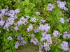 A lovely composite, no longer in the genus Eupatorium with the bonesets and Joe-Pye weeds, this is Blue Mistflower (Conoclinium coelestinum).
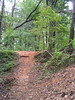
Bull Run Mountains loop
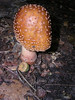
 After our recent heavy rains, the woods were exploding with mushroom fruiting bodies on today’s field trip to the Bull Run Mountains, under the auspices of the Virginia Native Plant Society and the Prince William Wildflower Society, host to the VNPS’ annual meeting. I wish that I had had such conditions when I was working through David Farr’s mushroom class last year.
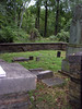
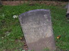 We hiked a state preserve property managed by the Bull Run Mountains Conservancy. The trailhead (within earshot of I-66) is on Beverley Mill Road, which parallels Virginia 55 through Thoroughfare Gap. Moving north, we crossed the railroad and moved into the area that was once the managed by the Chapman family. The family cemetery is compact, with most of the markers representing nineteenth-century passings, some of them quite premature.

 At the ruins of Meadowland, the family home, late-blooming Wingstem (Verbesina alternifolia) (in the Aster family) was still going strong. Smartweeds around here were prevalent, and I made a note to bone up on my Polygonum knowledge.
Our group was quite large, and it was only after we split into smaller groups to make the climb to the ridgeline that things felt completely organized. There was a temptation to hang back with the fern and lycophyte specialist leader as we moved up the Fern Hollow Trail—the hollows of this mountain are jumping with lycopdodium and other spore plants—but I pressed on with the climbers.
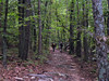
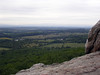 The ascent is fairly gentle, rising about 850 feet in 2 miles or so to the High Point Overlook. (The return felt a little more crumbly.) Going up, we paused to ID Pitch Pine (Pinus rigida). But the destination pine for this trip is Table Mountain Pine (P. pungens), found at the High Point overlook. The overlook, accessible through the indulgence of private property owners, is just over the line in Fauquier County, by my map reading. Also near the summit, False Foxglove (Aureolaria spp.) was isn bright yellow flower.
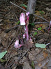
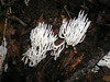
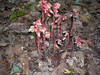 Coming back down, parasitoids seemed especially easy to find. Both species of Monotropa (Indianpipe in the left image and Pinesap in the right)…
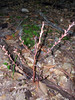 and a Broomrape family member, Beechdrops (Epifagus virginiana). This is a lovely natural area completely new to me, visited by not too many people, not far from D.C. (It’s just a few miles beyond the Gainesville split.) I will make it a point to return.