After a gloomy, drizzly start, the wet weather held off and we had a great field trip, led by Joe Marx, exploring several sites of geological interest in the Four Mile Run and Holmes Run stream valleys in Arlington County and Alexandria City.
 Setting out from East Falls Church Metro in the Piedmont, we paused to look at a cut in the stream bed of Four Mile Run to check out the alluvial layer from the last glaciation. The run slithers under I-66, skirting the so-called Brandymore Castle. At Joe’s fast pace, we climbed the castle, actually a lens of quartz from the middle Ordovician that protrudes into the landscape. The bedrock here is the Sykesville formation, a Cambrian schist, with bits of an even older actinolite intruding into it, and we found examples of both.
After a quick trip to Rosslyn to climb the first of five Tertiary period upland gravel terraces (the fifth and oldest forming the hill at Tysons Corner), we returned to Four Mile Run, farther downstream at the Long Branch Nature Center. We took a lunch break and indulged in some geology humor (Q: Where can you find the floodplain in Arlington County? A: Look for the picnic tables.) and did some sorting in the parking lot so that participants in Cliff Fairweather’s galls workshop got where they wanted to be. We stopped at Carlin Springs, now dry, but once a 19th-century resort stop on the W&OD railroad.
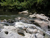
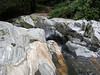 The high point of this stop was visiting a lovely cascade of Four Mile Run, relatively unmanaged and unchannelled, known as Hoffman’s Reach (sp?). Here the stream has carved potholes in the Cambrian-period Indian Run formation; granite intrusions into the pale gray rock are visible in the photos. Joe also pointed out a good example of the bedrock decaying into saprolite; a soil scientist, working top-down from the other direction, would call this the C horizon, which is quite thick in this area.
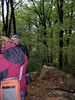
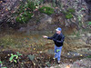 Our capstone stop was at the tiny sliver of a park in Alexandria named for Dora Kelley. Here, in the steep cut of a gully formed by a tributary of Holmes Run, Joe turned up an instance of the gravelly Potomac formation of the Coastal Plain (from 125 Mya) lying on top of the metasandstone of the Indian Run formation (from about 500 Mya). In the image, Joe is standing on loose gravel in the gully, and the rock exposure is behind him. The top horizontal edge of the dark, solid Indian Run rock is about even with Joe’s mid-thigh, and the layers of Potomac formation (gravel to clay) lie above.