
- A new niche scam: Someone has been impersonating Robert Faturechi, ProPublica reporter.
- A recap of rumors and misconceptions about the “missing” Georgetown Metro station, from the guy who wrote the book.
Did planners consider a rapid transit station for Georgetown?
Yes, but only in 1962 and 1963.
- Mid-century Malibu in paper matchbooks: I especially love the map to the Lindomar Lodge Motor Hotel printed on the inside of the matchbook cover. Some of the 50s gags are rather sexist, alas.
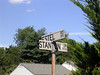
- From Mark Liberman of Language Log and Clare Downham, a poster of UK regional names for alleyways. Lemony Snicket revealed. I’m idly working on something about American practice of double-naming thoroughfares, like Street Road in Bensalem, Pa. and elsewhere.
Category: Graphic Design
A mystery: 28
The Southwest Virginia Historical Museum in Big Stone Gap is a mini-Smithsonian in the sense that it’s a collection of artifacts that someone once found interesting and/or valuable. (What I found most interesting was the red oak woodwork throughout the mansion.)

 In the collection is a set of china from Minton. A gift from Queen Victoria to her Prime Minister Benjamin Disraeli (27 February 1868 – 1 December 1868, 20 February 1874 – 21 April 1880), it came into the possession of Campbell Slemp. All of the pieces are marked with a monogram formed from a pair of interlocked B’s, topped with a crown and bearing the motto HONI SOIT QUI MAL Y PENSE. So far, so good, appropriate to a monarch. But what about the linked B’s? Who dat? They don’t fit Victoria nor Disraeli, as far as I can figure.
Think of the young designers
 Typographic mayhem at The New Yorker. From top to bottom: issues of 11 May 2020, 18 May 2020, 25 May 2020, 8-15 June 2020 (Fiction Issue), 22 June 2020. Is it all an A/B test gone horribly wrong? #freeIrvin
Some links: 75
Birds, habitat, coffee agriculture—and 10 ways of looking at Northern Virginia.
- Rex Graham summarizes the research of Daniel Karp, who established the link between insectivorous birds on coffee plantations and control of the Coffee Berry Borer (Hypothenemus hampei).
- Ted Floyd goes birding at Bon Secour NWR and reminds us of the differences between National Parks and National Wildlife Refuges.
- Alonso Abugattas gives a shout-out for the most awesomest North American anatid, the Wood Duck.
Silver Line progress report: 32
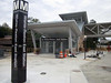
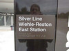 Sandbox John gave me the tip that signage was in place at the Wiehle station. The typography appears to be a mix of the heavier-weight Helvetica that has been used in the system from the start (over the station entrance) and a lighter weight on the pylon. I’m also seeing this fresh-looking lighter weight in new platform location signs along the Blue and Orange Lines downtown; the signs set aside empty space for the Silver Line route information to be added when the Line goes live.
John also reports:
The north end of the pedestrian bridge at the Wiehle-Reston East station is a little interesting. It just ends at the corner of the plaza of the Comstock Partners Reston Station property. No sloping canopy like at the bottom of the escalators at the entrance pavilions. There also is no entrance pylon marking its purpose. Adjacent to the end of the pedestrian bridge is a set of stairs that descend to the loading dock access road to the buildings that have not been built yet. Not sure why it is there, best guess is it there to allow access to the north side of the station from the location where the fire trucks would connect fire hoses from the fire hydrant to the dry standpipe.
Close enough
When reality gives way to art: somewhat fanciful behavior is pictured in a splendid poster (ca. 1926) by Oscar Rabe Hanson promoting commuter rail service in Chicago, part of a long article by J. J. Sedelmaier. The ducklings following the adult Wood Duck would more likely be single file, and more closely bunched. More critically, the little ones would be following a hen, not a drake.
No Viking dragon boats
A pleasant change, at least in this Helvetica skeptic’s eyes: the Central Park Conservancy is rolling out new signage parkwide, set in Titling Gothic. Very nice set of images by David W. Dunlap that capture the historical range of fonts and styles of signs in the park.
(Link via The Morning News.)
Silver Line progress report: 15
Via DCist, Lydia DePillis reviews options for Metro’s rail map redesign in anticipation of Silver Line service. I like Cameron Booth’s proposal, a Vignelli-ish elongation of the design elements that also incorporates connections to commuter rail. DePillis touches my hot button:
…the most infuriating part of the map for graphic designers are the absurdly long station names that have crept into the system over the years, like “U St./African-Amer Civil War Memorial/Cardozo” and “Woodley Park-Zoo/Adams Morgan.” They have to be squished in diagonally and even break over route lines—a no-no to transit design purists. … just a brief glance at the now-barely-readable fare charts in stations, after “peak of the peak” pricing debuted, shows how confusing signage gets when it tries to convey too much.
Classic
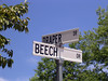
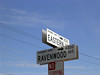 On my last trip to California, I was dealing with family business, so I didn’t in get much sightseeing or birding—none, really. But I did start building my collection of West Coast street name signs with this easy-to-read example from Arden Arcade, an unincorporated suburban area of Sacramento County. The arrows (which don’t appear consistently) indicate the direction in which street numbers increase.
More mistakes
Jennifer 8. Lee tours the New York subway system with Paul Shaw, author of “The (Mostly) True Story of Helvetica and the New York City Subway,” (linked previously) and takes lots of pictures.
Or, How a mistake by the fabrication shop became a design element
Via The Morning News, Paul Shaw tells “The (Mostly) True Story of Helvetica and the New York City Subway” in a deliciously-illustrated nine-page essay, which includes digressions into the history of the system map, the Chrystie Street Connection snafu, and a refresher on 1970’s-era type technology.
Big pixels
Christoph Niemann tiles the bathrooms of his renovated home with renderings of 20th-century icons of art and graphic design.
“I wanted a Titian and all I got was a lump of lard,” Lisa gasped.
Mishmash
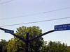
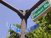
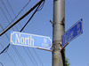
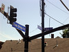
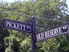
The street name signs in Fairfax City constitute the most egregious mess of colors and styles in the metropolitan area.
 The smaller intersections are marked with generic black on white signs, with or without block numbers. These simple, functional signs are similar to those used in Arlington County.
 Up on the busier thoroughfares, the signs switch to white on blue. Most use a readable but pedestrian all-caps sans serif. Overhead signs use “Freeway Gothic” in mixed case.
 There is a pinched condensed font that suggests credits on a movie poster. (Unfortunately, an example or two of this developer-friendly sign can be found in Reston, too.) The contrast with the white on green is particularly ugly.
 Intersections in the old town center use signs with a scrolled border and a decorated serif, but recent traffic re-engineering is replacing these with the ordinary overheads.
 This example, missing the street type and the block numbers, appears to be a one-off. Notice the brackets for the crossing sign for University Drive, which is missing.
 You can even find a few examples of this jaunty mixed-case sans serif, shown here with an afterthought black and white locator.
 This blue-bronze sign for a new subdivision of starter McMansions is especially galling.
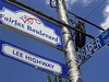
 But the worst specimens accrue to the recent dual-designation within the city of U.S. Route 50, which follows Arlington Boulevard, Lee Highway, and Main Street, as “Fairfax Boulevard.” This led to the creation of these red-white-and-blue decorative contraptions. Notice the oops-addition of a sign for Blake Lane, which was extended to this intersection about 20 years ago.
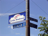
 Minor intersections were fitted with smaller versions of the ungainly, squareish Fairfax Boulevard signs.
Related: My pedantic nuthatch posts from ’05 and ’06 on street name signs in Reston, Fairfax County, Lake Barcroft, Alexandria, Arlington, Bethesda, and the District.
TE/XTP/REFS
Via i love typography: tell the people at the Text Prefs project what font, size, and spacing is most readable for you.
fargo
I scored 25 out of 34 in The Rather Difficult Font Game. Not good enough to make it on to the leader board.